3-6 inches of Snow is Expected Across Parts of New Jersey

Valentine’s Day Promotions for Jersey Shore BlueClaws Fans
February 7, 2025
Man Sentenced to Eight Years for Role in Gruesome Murder Case
February 7, 20253-6 inches of Snow is Expected Across Parts of New Jersey

Second Winter Storm
Parts of New Jersey are predicted to receive 3–6 inches of snow on Saturday and Sunday, with additional snowfall predicted on Tuesday–Wednesday and possibly again by Friday according to News12NJ Storm Watch.
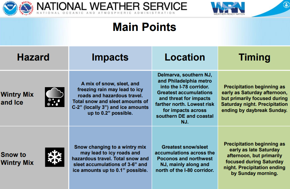
On Saturday night and into early Sunday, a winter storm is predicted to bring 3–6 inches of snow to northern New Jersey, with up to 9 inches possible in Sussex and northern Passaic counties.
On Saturday, the storm begins after 5 p.m. and the snow continues all night. In central Monmouth, southern Middlesex, and all of Mercer counties, where snow builds up initially before a mixture of rain, sleet, and snow moves through to compact any snowfall by Sunday morning, there will be a dramatic cutoff of snow totaling 3-6 inches and 1-3 inches.
In addition to sleet and freezing rain, forecasters predict that the storm will bring icy conditions and heavy snow in some places.
Up to 6 inches of snow is predicted in some areas and 3 to 5 inches north of Interstate 78.
The National Weather Service predicted that South Jersey would receive less than an inch of snow, while Central Jersey would receive one to three inches.
According to National Weather Service, snow, sleet, and freezing rain are all expected in a messy mixed bag of wintry precip from Saturday afternoon through Sunday morning. Many locations will start as light snow before changing over to a wintry mix Saturday evening and overnight.
Exact timing of precipitation types and forecast amounts remain uncertain.
How much sleet mixes in with the snow will determine how much snow falls in the end.
According to the weather service, the storm begins with snow on Saturday afternoon and evening, transitions to sleet and freezing rain during the night, and ends as just plain rain by Sunday morning.
During the storm, which will move from south to north, slippery roads will be a problem.
The five counties in the northeast are already under a winter storm watch. In the counties of Bergen, Essex, Hudson, Passaic, and Union, the watch is in effect from 7 p.m. on Saturday until 11 a.m. on Sunday.
Another system will bring potential for more significant snowfall accumulations on Tuesday and Tuesday night. This snow may impact the Tuesday morning and Tuesday evening commutes. Always stay up to date with the latest forecast.


