Rock Legend Bruce Springsteen Makes Surprise Visit to Freehold Restaurant
December 16, 2023New Jersey Police Seeking Public’s Assistance with Road Rage Shooting Investigation
December 17, 2023
Jersey Shore Braces for Late Sunday Storm
Flood warnings were issued in advance of the rainy, windy weekend storm that might cause floods. The New Jersey region is preparing for a severe storm for the second week in a row. On Sunday and Monday, heavy rain and high gusts are predicted, raising the possibility of floods and power disruptions. You can check for power outages near you here.
The
National Weather Service says the moisture-packed storm will probably pack a big punch in terms of soaking downpours, street flooding, potential coastal flooding, and damaging winds, even though the forecast hasn't changed much in the last 24 hours.
16 counties—Atlantic, Burlington, Camden, Cape May, Cumberland, Gloucester, Hunterdon, Mercer, Middlesex, Monmouth, Morris, Ocean, Salem, Somerset, Sussex, and Warren—have been placed under a flood watch—which is not as serious as a warning—ahead of the storm.
The watch is in force from Sunday evening through Monday afternoon and acts as a warning that there may be flash flooding or longer-duration flooding due to overflowing creeks, streams, or rivers.
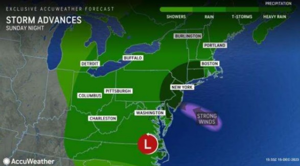
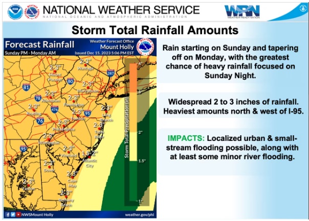
According to Accuweather, rain would start to fall on Sunday afternoon and continue until Monday morning or early Monday afternoon, with totals between two and three inches by the time the storm passes. (AccuWeather predicts two to four inches of rain in our area.) Before it slack off, the majority of the rain is probably going to fall Sunday night and into Monday morning, making for a convoluted commute.
Forecasters indicate that the coastal storm's most likely route will likely concentrate the strongest bands of rain in areas north and west of Interstate 95, with slightly lower totals projected in the southeast of the state of New Jersey.
POWERFUL WINDS
During the storm's peak later Sunday and early Monday, wind gusts along the Jersey Shore might occasionally reach as high as 40 to 50 mph, while in interior parts of the state, gusts could reach as high as 30 to 40 mph. There would be sporadic power interruptions due to the strength of the higher gusts.


