Winter is Far From Over in NJ. Here is What to Expect

Search Underway for Missing 30-Year-Old Woman in New Jersey
February 3, 2025
Sheryl Middleton’s Inspiring Journey in the Battle Against Cancer
February 3, 2025Winter is Far From Over in NJ. Here is What to Expect

Winter is Far From Over in NJ. Here is What to Expect
On Sunday night, there were some conversational snow showers to cap off the cold weekend.
We will have one mild day to begin the workweek, so if there is snow on the ground, it won't last long. Monday afternoon temperatures in South Jersey might reach 50 degrees, which is pleasant but not warm.
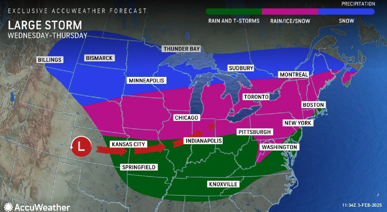
Tuesday turns blustery. After that, forecasters will focus on a complex storm system that is expected to arrive late Wednesday.
With a chaotic transition from snow to icy mix to rain, it's time to start raising alarms about that storm system that is expected to occur in the middle of the week. By Thursday morning, travel throughout the state is predicted to be simultaneously wet, slushy, icy, and snowy.
On Saturday at the end of the week, another storm system of a similar nature is expected. And a couple more the following week.
With temperatures plunging well into the 20s, Tuesday night will be extremely cold.
Our next storm system's precise location and timing are still very much up in the air. However, there is a clear indication that a "mess" will begin late Wednesday.
Last month, AccuWeather Lead Long-Range Forecaster Paul Pastelok stated, "We are monitoring three potential storms between Feb. 5-11." "There may be travel and business disruptions due to this busy pattern."
Accuweather also states a wintry start to our "main event," thanks to that cold air, as low pressure moves in from the southwest on Thursday night. For the majority of the state, precipitation might not begin until after midnight. Snow will probably be the first type of precipitation for everyone.
The western edge of New Jersey is then likely to experience a change from straight snow to more of an icy mix as warmer air bubbles up from the south.
A real "ice storm" is the obvious worst-case scenario here, and a spell of sleet and freezing rain could create a very icy scene.
Around daybreak on Thursday, plain rain is expected to shift into southern and coastal New Jersey.
However, on Saturday, our next storm system will arrive. Once more, it doesn't appear to be a snowstorm. However, prior to the influence of mixing and precipitation, current forecast models do depict a relatively snowier solution. Therefore, if this forecast is accurate, North Jersey in particular may see more than "a few inches" of snow accumulation.
Three more storms are possible for next week, according to long-range forecasts. Wednesday, Friday, Sunday, or some other time in the vicinity. However, that doesn't mean those will be snowmakers. For any or all of them, a rainy pattern could be pushed toward us by any sign of warm air. We will have to wait and see.


