Nasty Weekend Storm Expected in NJ: Snow, Ice, and Heavy Rain Ahead

Firefighters Respond to Accidental Residential Fire in Toms River
February 13, 2025
Woman Charged After Teen and Pets Found in Filthy Conditions in Ocean County
February 14, 2025Nasty Weekend Storm Expected in NJ: Snow, Ice, and Heavy Rain Ahead

Snow, Ice, and Heavy Rain Ahead
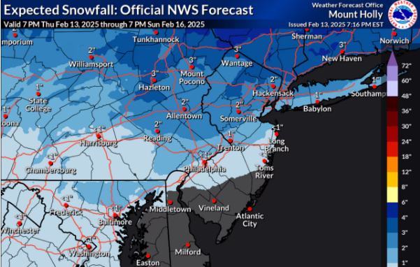
On Saturday afternoon and evening, northern New Jersey may receive 2 to 4 inches of snow before it starts to rain. As the temperature rises, Sunday is predicted to see more heavy rainfall. Flooding could be a concern if rainfall totals reach two inches. AccuWeather.com and the National Weather Service
Ice conditions are a concern as precipitation begins with snow and turns to rain as temperatures rise into Sunday, as has been the case with several storms in the past week.According to the weather service, "snow will mix with and turn into sleet and freezing rain towards the I-78 corridor into Saturday evening, with the possibility of several hours of a wintry mix before an eventual change to rain."
"This zone and areas northward are expected to receive 2 to 4 inches of snow and sleet, with a tenth to a quarter inch of ice possible."
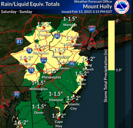
Sunday is going to be mostly rainy, with highs reaching the 50s and even 60s in some places.Rainfall and snowmelt could cause flooding, with up to 2 inches of precipitation predicted.
According to the NWS, there may be some thunderstorms in southern New Jersey on Sunday.
The rising temperatures However, Sunday is probably going to be a short respite from the cold.
It feels much colder to start the week as a cold front moves in on Sunday night, bringing temperatures below freezing once more and winds of up to 40 mph.
Although the track is still unclear at this point, forecasters are keeping tabs on the possibility of a major winter storm on Wednesday.
Check Out the Latest Forecast.


