A Winter Storm Watch has been Issued for New Jersey Ahead of a Weekend Nor’easter That May Dump Up to a Foot of Snow

In Atlantic City, the World’s Largest Oceanfront Indoor Waterpark is Set to Open 2023
January 26, 2022
The ‘Undercover Boss’ of Rita’s Italian Ice in Toms River Uncovers an ‘Amazing’ Story of Franchisee Owner
January 27, 2022A Winter Storm Watch has been Issued for New Jersey Ahead of a Weekend Nor’easter That May Dump Up to a Foot of Snow

Photo Credit: NWS
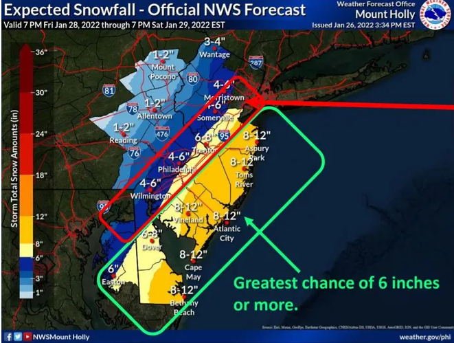
A winter storm watch was issued for most of New Jersey early Thursday morning, with the National Weather Service now predicting up to a foot of snow in every county along the Jersey Shore.
According to the weather service, the watch will go into place at 7 p.m. Friday and will last until 7 p.m. Saturday. After 7 p.m. Friday, snow is forecast, with a low air temperature of around 20 degrees on Friday night. After midnight, a north wind of 5 to 10 mph will build to 15 to 20 mph. There is a 90% chance of snow on Friday.With a high at 26 degrees and a north wind of 20 to 25 mph, with gusts as high as 35 mph, the snow will continue to fall on Saturday. There's an 80% probability of snow on Saturday.
According to the weather service, conditions will be "blustery" during the storm.
The intensity of the impending nor'easter remained unknown as of Wednesday night. Between now and Friday night, even the tiniest movement in the storm's track may mean the difference between a few inches and more than a foot of snow.
Meteorologist Steven DiMartino, who runs the website nynjpaweather.com, said in a webcast Wednesday night that snowfall totals might be significantly disproportionate in spots as close as 20 miles apart.“Like, for example, Philadelphia ends up with 2 inches, but then Mount Holly or Freehold ends up with over a foot of snow. I can definitely see that happening,” DiMartino said. “I could see 20 inches in Belmar and 3 inches in Trenton. I could see that happening, based on the evolution of this storm.”
DiMartino told his viewers on Wednesday that his latest prognosis, based on his study of the two, predicts 10 to 14 inches of snow for parts of the Jersey Shore. "And, by the way," he added, "severe coastal flooding."Currently, the meteorological service is being cautious in its forecasting, stating that there is a "potential for heavy snow accumulations of 6 inches or more across areas of the region" on Saturday, as well as "moderate coastal flooding probable."
Between I-95 and the ocean, the storm will be at its worst, with New Jersey and Delaware bearing the brunt of the damage in the Mid-Atlantic region. Nonetheless, the situation is still evolving, and the forecast may alter.

