Earthquake Rattles Several Areas in New Jersey
January 2, 2024What to Expect: Weather Alert for Jersey Shore’s Coastal Storm
January 5, 2024
Prepare for a Powerful Weekend Storm at the Jersey Shore
According to the National Weather Service, they are continuing to monitor the potential for an impactful storm arriving in the area Saturday and Sunday, January 6th-7th. While there remains a great deal of uncertainty with this storm, parts of the forecast area have the potential to see impactful winter weather.
The latest information regarding this system is below:
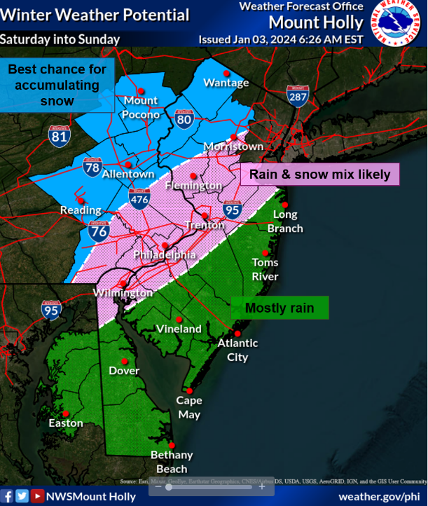
Wintry weather is likely for interior portions of the forecast area, mainly north & west of the Fall Line across our higher elevations, as the system moves into the region late Saturday into Sunday. A great deal of uncertainty remains regarding precipitation type and amounts, which is dependent on just how much cold air is available and the exact storm track.
The greatest probabilities for snowfall will occur along the I-78 corridor and points north & west. Areas along the I-95 corridor could see some snow and/or a wintry mix of precipitation, but this remains highly uncertain. Again, details regarding precipitation types and amounts remain far from being worked out. See the attached snowfall probabilities graphics for details.
The most recent rainfall prediction has reduced; throughout the region, 0.5 to 1 inch of rain or liquid equivalent is anticipated, with locally greater amounts likely. Although the risk has diminished from NWS prediction yesterday, localized flooding is still conceivable given the antecedent circumstances, particularly the extremely saturated ground and strong flows that are still present on the majority of rivers and streams.
Nevertheless, because of the saturated grounds, several areas of the region are still at marginal risk of receiving excessive rainfall.
Gusty winds up to 20 to 30 mph are possible inland, with gusts as high as 35-40 mph along the coast. Extra precautions may need to be considered considering recent heavy rains and soggy ground.
Coastal flooding will be a concern for all coastal communities. At this time, it is too early for specifics on which communities may see the greatest impacts and what magnitude, if any, the flooding may reach.


