For Some Workers in New Jersey, the Minimum Wage Has Increased to $13
January 1, 2022Toms River Regional Schools Will Stay Open Despite Spike in COVID-19 Cases
January 2, 2022
A Winter Storm Watch was Issued Sunday Morning
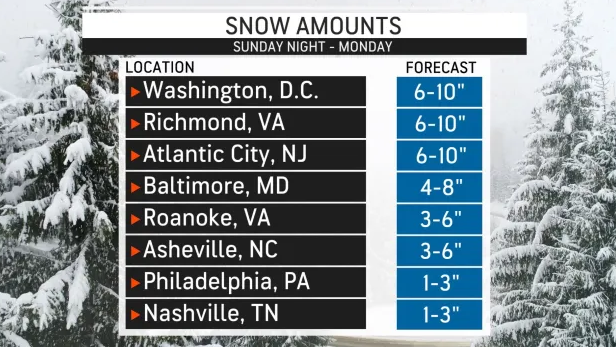
Are you returning to work or school on Monday? As substantially cooler air rushes in, a sneaky storm from the south will swing northward and strengthen enough to pelt parts of the mid-Atlantic region with heavy snow, according to AccuWeather meteorologists.
While the exact track and power of the southern US storm is changing by the hour, the components are in place for snow to fall at a heavy pace of 1-3 inches per hour in parts of the mid-Atlantic on Monday. The northern reach of the heavy snow has yet to be determined.
"Given the warmth and lack of wintry weather thus far this season, it may be difficult to believe that any snow is on the way," AccuWeather Meteorologist Ryan Adamson said, warning that the situation will be dramatically different by Monday morning.
Even though the weather seemed like spring for much of the New Year's holiday weekend, with highs in the 50s and 60s F, the atmosphere is fast shifting gears and is ready to drop temperatures by 30-40 degrees Fahrenheit in a couple of hours from Sunday night to Monday.
The storm buildup will be a mile-by-mile battle. If the storm moves several hundred miles north, Washington, D.C., Baltimore, and Richmond, Virginia, may not be the only big cities along Interstate 95 to get significant snowfall. Flakes might fall quickly enough to cover parts of the zone from Philadelphia to New York City with several inches of snow.
When it comes to heavy snow vs. flurries vs. nothing at all, how far north or south the storm tracks is crucial. With this storm, a distance of 30 miles might be the dividing line for all three zones. This means that weather conditions on Monday can be drastically different depending on whether you're seeing friends or family, or if you're visiting a home or company a short distance away.
There is the potential for 6-12 inches of snow to accumulate in the storm's core, with locally greater amounts. At this time, heavy snow is most expected to fall from eastern Virginia to Maryland's eastern shore, as well as portions of Delaware and southern New Jersey.
Parts of Atlantic, Burlington, Cape May, Cumberland and Ocean counties will see the largest snowfall totals, while areas as far north as Monmouth, Middlesex and Mercer counties could see a coating to an inch of snowfall.


