
NJ Weather: Another Round of Storms, Then the Heat Cranks Up

PUBLIC ALERT: FALSE CLAIMS CIRCULATING — MARIAH A. HETZEL IS STILL MISSING
September 2, 2026
Staten Island Man Survives Direct Lightning Strike — “I’m Blessed to Be Alive”
September 2, 2026NJ Weather: Another Round of Storms, Then the Heat Cranks Up

NJ Weather: Another Round of Storms, Then the Heat Cranks Up
Scattered showers and thunderstorms are expected to move back into parts of New Jersey Wednesday night and continue into early Thursday, with another round of storms possible Thursday afternoon, according to forecasters.
The exact timing remains uncertain, but some storms could turn severe, bringing wind gusts of up to 60 mph. Those powerful winds could knock down trees and power lines, forecasters warn.
Heavy rainfall could also affect parts of New Jersey, although widespread flooding is not expected, according to the National Weather Service.
The agency’s Mount Holly forecast office warned Wednesday afternoon that periods of intense rain could lead to localized flash flooding in some areas.Beyond the threat of rain and thunderstorms, New Jersey is also expected to see hot and humid conditions return Thursday.
High temperatures could reach the upper 80s to mid-90s across much of central and southern New Jersey, while northern parts of the state are expected to see highs in the low to mid-80s.
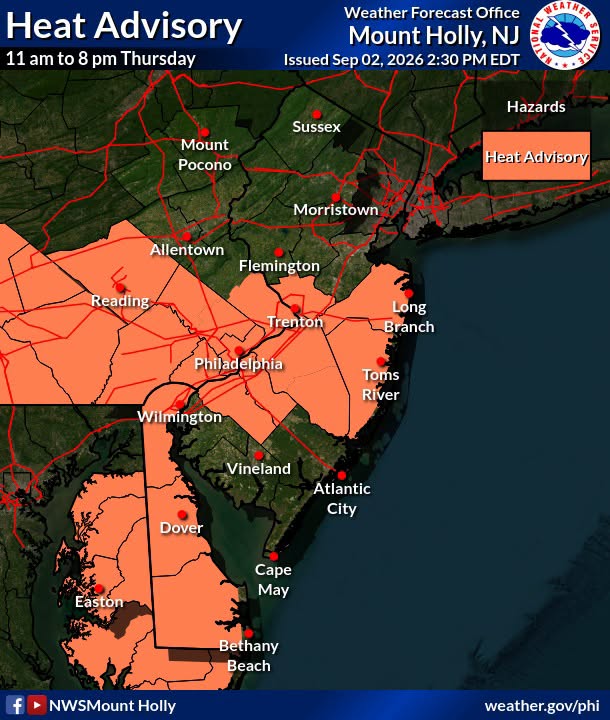
High humidity is expected to make it feel even hotter, with heat index readings climbing into the mid-90s to low 100s in areas south of the Interstate 78 corridor, according to the National Weather Service.
A heat advisory will be in effect from 11 a.m. to 8 p.m. Thursday across Burlington, Camden, Gloucester, Mercer, Monmouth and Ocean counties.Thursday could bring another round of severe thunderstorms, particularly during the afternoon and evening. The Storm Prediction Center has placed areas as far north as the Interstate 78 corridor under a marginal risk, or level 1 of 5, for severe weather.
Forecasters say the strongest storms could produce damaging wind gusts and large hail, depending on how conditions evolve.
Friday is expected to be partly sunny, although a few showers could develop later in the day.
The outlook improves significantly for Labor Day weekend. New Jersey is expected to enjoy mostly sunny skies, dry weather and comfortable temperatures, with highs in the upper 70s forecast Saturday through Monday.


