
Powerful Storms Will Slam New Jersey, Bringing Heavy Rain and Flash Flood Threat

NJ Resident Killed by Falling Branch in Storm
July 5, 2026
Tips Needed for Brooke Hanlon’s Suspicious Passing
July 5, 2026Powerful Storms Will Slam New Jersey, Bringing Heavy Rain and Flash Flood Threat

Powerful Storms Will Slam New Jersey, Bringing Heavy Rain and Flash Flood Threat
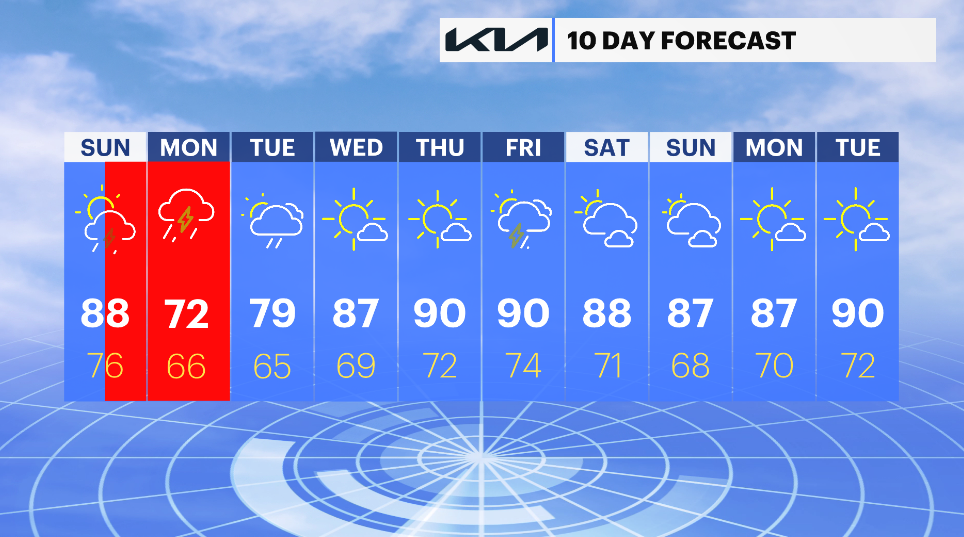
The focus shifts to heavy rain and thunderstorms after a few days of intense heat. Although today's highs in the 80s will feel somewhat better than the previous triple-digit heat, it will still be extremely hot. Even though we've already got our fair share over the past few days, flooding will be a concern if there are more widespread storms.
With gusty to destructive winds in the heaviest of storms, the first round begins this afternoon and continues into this evening. There will be a lot of storms and a lot of rain on Monday, so allow additional time for both trips. Because of all of this, there is a risk of flash flooding when storms move over the same area for hours and dump inches of rain in a brief amount of time.
New Jersey residents should prepare for a wet and potentially dangerous stretch of weather as multiple rounds of powerful thunderstorms are expected to move across the state over the next 24 to 36 hours.
Forecasters are warning that repeated waves of heavy rain could lead to localized flooding, especially in low-lying areas, urban locations, and places with poor drainage. Some communities could see several inches of rainfall before the storm system exits the region.
A flood watch has been issued for much of the state as meteorologists monitor the potential for flash flooding. The greatest concern will be areas that experience multiple rounds of thunderstorms, which could quickly overwhelm storm drains, creeks, and small streams.
In addition to heavy rainfall, some storms may produce frequent lightning, gusty winds, and brief periods of torrential downpours that could significantly reduce visibility for motorists. Travel conditions may become hazardous during the heaviest rain, particularly during periods of peak traffic.
The National Weather Service advises residents to remain alert for changing weather conditions and to never drive through flooded roadways. Just a small amount of moving water can sweep vehicles off the road, making flash flooding one of the most dangerous weather hazards.
Emergency officials are encouraging residents to secure outdoor items, clear storm drains where possible, and have multiple ways to receive weather alerts, especially overnight when storms may continue moving through the region.
The unsettled weather pattern is expected to continue through the next day before conditions gradually improve. However, additional showers and thunderstorms could develop at times, prolonging the flood threat in some locations.
Residents should closely monitor local forecasts and be prepared to take action if flash flood warnings are issued for their area. With saturated ground and repeated rounds of rain expected, even areas that do not typically flood could experience problems as the storms move across New Jersey.


